
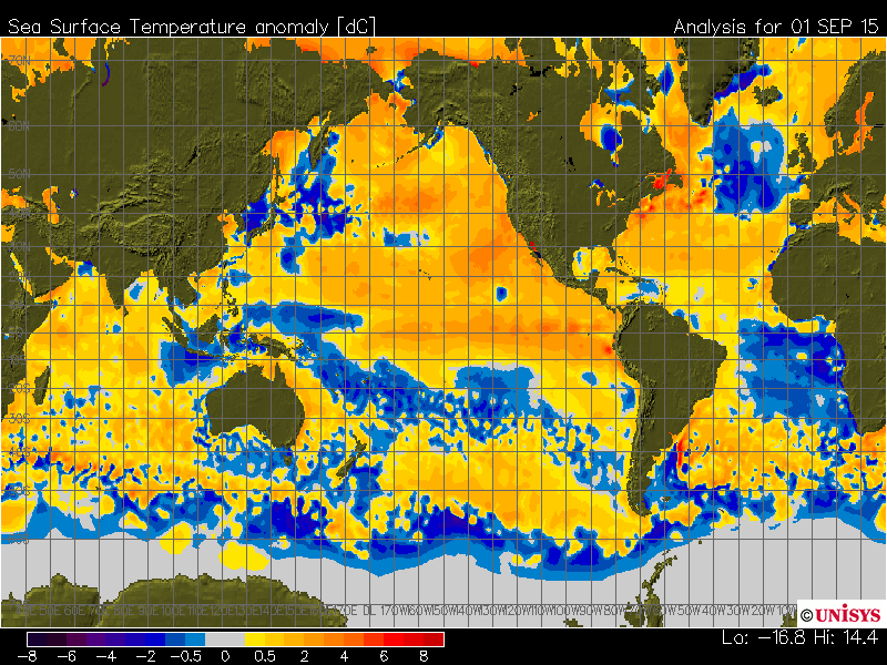
All of the warm water at the surface of the Pacific, and the major hurricanes that have been occurring there – are radiating huge amounts of heat out into space. The Pacific is likely losing record amounts of heat this summer. Note the cold spots starting to appear around Hawaii where typhoons have passed.
Disrupting the Borg is expensive and time consuming!

Recent Comments
Bob Greene on CBS News 1982 : One Fourth Of… willys36 on “Why Scientific Fraud Is… gelcarrion0t on “Why Scientific Fraud Is… gelcarrion0t on Climate Friendly War saveenergy on Climate Friendly War Morgan Wright on “100% Non-Carbon By 2030… saveenergy on “100% Non-Carbon By 2030… gelcarrion0t on “100% Non-Carbon By 2030… TimC on “100% Non-Carbon By 2030… TimC on “100% Non-Carbon By 2030…
Reblogged this on Give Me Liberty.
You really have to question whether the SST is that warm IMO. Dr. Ryan Maue showed some good stats on the trends around the 10th anniversary of Katrina:
Total Global Accumulated Cyclone Energy (ACE) Sep 1985 – Aug 1995: 8102 Sep 1995 – Aug 2005: 8310 Sep 2005 – Aug 2015: 6676
120-months before Katrina 491 global hurricanes, 253 were major 120-months since Katrina 430 global hurricanes, 234 were major
Since hurricanes are the planet’s natural air conditioning warmer should mean more storms. Where are they? 10 years a good interval. Maybe not so warm like everything else they do.
https://weather.gc.ca/data/saisons/images/2015090200_054_G6_global_I_SEASON_tm@lg@sd_000.png
https://weather.gc.ca/saisons/animation_e.html?id=month&bc=sea
The ONI index is showing a not so strong El Nino so far,
http://www.cpc.ncep.noaa.gov/products/analysis_monitoring/ensostuff/ensoyears.shtml
It looks comparable to the moderate episode of 2006-07.
The heat seems localized mostly in the N. Pacific, IMO, the Atlantic and S Pacific are near normal or below normal
http://ocean.dmi.dk/satellite/plots/satanom.gbl.d-00.png
I agree with Steve that the N. Pacific is loosing energy fast, the PDO+ is quickly going down, as happened in similar previous spikes, the anomaly decreased by more than 1C since the beginning of this year,
http://www.climate4you.com/images/PDO%20MonthlyIndexSince1979%20With37monthRunningAverage.gif
I think solar radiations are also playing an important role and should help to accelerate the process in the final months of this year.
N. Pole temperatures are not very warm,
https://dmhscratch1.files.wordpress.com/2015/07/dmi-n-pole-temperatures-sep-02-2015.jpg
as happened in 2007
http://ocean.dmi.dk/arctic/plots/meanTarchive/meanT_2007.png
and 2012,
http://ocean.dmi.dk/arctic/plots/meanTarchive/meanT_2012.png
In general satellite measurements show world’s temperatures falling in the present “El Nino”, which is exactly the opposite of what happened in 1997-98, 2009-10, and even 2006-07
https://dmhscratch1.files.wordpress.com/2015/07/woodfortrees-rssuah-from-1995-to-2016.jpg
What is happening now looks like a different phenomenon than the previous moderate or strong El Nino’s.
AMO has a very large impact on temperature.
http://woodfortrees.org/graph/rss/from:1979/plot/esrl-amo/from:1950
Good point, the AMO flipped positive in 1994-95 and could be changing back to negative again.
Now, is the AMO just a reflex of the world’s temperatures changes or is it a *cause* of these changes to some extent?
The area in the N. Atlantic that is used to determine the AMO index is too small, I tend to think that it’s only reflecting the trend of global temperatures.
In general satellite measurements show world’s temperatures falling in the present “El Nino”, which is exactly the opposite of what happened in 1997-98, 2009-10, and even 2006-07
Pretty crazy, huh. I’m wondering what it all means.
UAH shows warming:
http://www.drroyspencer.com/wp-content/uploads/UAH_LT_1979_thru_August_2015_v6.png
It is interesting in your reference to ACE for the period ending in 2005. I think the seasons of 2004 and 2005 were the most active hurricane cycles we’ve recently experienced. And I think it is no accident that after those active years ocean temperatures started declining, and soon to follow atmospheric temperatures.
I think the oceans help to seek equilibrium in the coupled atmosphere/ocean system. From what I see, both are giving up more heat than they are retaining. This points to a cooling cycle more than a warming one. I would much prefer things get warmer!
http://www.hyzercreek.com/sciMethod.jpg
Above is frightening in its accuracy.
Very well done!
What has happened to the Gulf Stream?
http://earth.nullschool.net/#current/ocean/surface/currents/orthographic=-43.06,36.43,690
http://earth.nullschool.net/#2015/09/07/1200Z/wind/isobaric/850hPa/overlay=temp/orthographic=-2.93,54.55,910
Thanks for the link
AMO starting to shift into negative… probably.
Doesn’t anyone find it interesting that El-Nino ocean warming begins off the south American coastline right where 5 continental plates are jostling each other as part of the area known as the Ring of Fire and then spreads over the Pacific ??
Undersea volcanic activity in an area known as the Ring of Fire couldn’t possibly account for El-Nino ocean warming ? It must be the atmosphere with its 2 – 3 percent concentration of greenhouse gases at 1/1000th the density of water.
El Nino is caused by a lack of east to west winds, which normally create low pressure along the South American coast and pull cold water to the surface.,
Of course my perspective was from Australia and the south Pacific.
The north Pacific shows similar heating along the Ring of Fire.
Volcanic activity seems to be more intense lately – no major eruptions but a lot of moderate activity from various parts of the globe. Seems to be several years of elevated volcanic activity.
I don’t pretend to know what causes El-Nino but lava at up to 1200 degrees C can cause ocean heating. The number and location of undersea volcanoes is unknown as is the activity associated with these but the Ring of Fire is apparently the most active volcanic area we know of.
And a gradual bulging of some part of the oceans floors could easily account for the small but steady sea level rise and no-one would ever know it.
The Earth’s surface moves!
Underwater volcano is also active off the coast of Oregon (blob).